This is preliminary information, subject to change, and may contain errors. Any errors in this report will be corrected when the final report has been completed.
https://registry.faa.gov/AircraftInquiry/Search/NNumberResult?nNumberTxt=N250MK
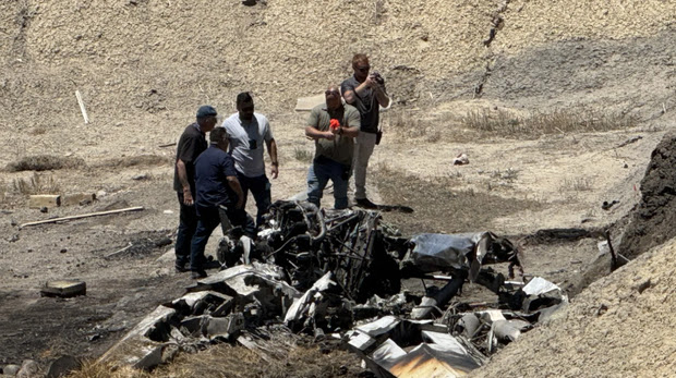
Figure 1: Wreckage
On June 23, 2025, at about 1000 local time, a privately-registered Murphy Moose, N250MK, was destroyed when it impacted terrain near Montrose Regional Airport (MTJ/KMTJ), Montrose, Colorado. The pilot and passenger were fatally injured. The The airplane was operated as a Title 14 Code of Federal Regulations CFR Part 91 personal flight, which originated from MTJ, and was destined to an unknown location.
A witness reported seeing the aircraft in a right turn after takeoff until it hit an embankment, overturned and caught fire. It is still not confirmed which runway was used for takeoff.
- Pilot Info:
The pilot, aged 61, held an airline transport pilot certificate, with a rating for airplane single engine land and airplane multi-engine land. He also held commercial privileges for airplane single engine sea. He also held a flight instructor certificate (valid until 31 MAR 2026) and airframe and powerplant (A&P) certificate. The pilot held type ratings in the Boeing 757, Boeing 767 and Douglas DC-8. The pilot's first class FAA medical was issued on February 2025, with a note about wearing corrective lenses to meet vision standards at all required distances.
- Airplane Info:
The accident airplane, MSN 001, was manufactured in 2008. It was powered by a Vedeneyev M14P engine. According to the FAA registry, "This aircraft's registration status may not be suitable for operation." It is unknown if this is outdated or not.
The accident airplane, MSN 001, was manufactured in 2008. It was powered by a Vedeneyev M14P engine. According to the FAA registry, "This aircraft's registration status may not be suitable for operation." It is unknown if this is outdated or not.
- Airport Info:
Montrose Regional Airport is a public airport located about 1 mile northwest of Montrose, Colorado. The airport sits at an elevation of 5758 ft. It features two asphalt runways 17/35 (10000 x 150 ft) and 13/31 (7510 x 100 ft).
Montrose Regional Airport is a public airport located about 1 mile northwest of Montrose, Colorado. The airport sits at an elevation of 5758 ft. It features two asphalt runways 17/35 (10000 x 150 ft) and 13/31 (7510 x 100 ft).
- Weather:
METAR KMTJ 231553Z AUTO 30007KT 10SM CLR 19/M04 A3017 RMK AO2 SLP145 T01891039
METAR KMTJ 231653Z AUTO 31006KT 10SM CLR 21/M02 A3016 RMK AO2 SLP139 T02061017
The density altitude was calculated at 7338 ft.

No comments:
Post a Comment