Wednesday, May 14, 2025

Honda HA-420 HondaJet, N826E, accident occurred on April 7, 2025 at Southwest Oregon Regional Airport (OTH/KOTH), North Bend, Oregon

 This is preliminary information, subject to change, and may contain errors. Any errors in this report will be corrected when the final report has been completed.

Aviation Accident Preliminary Report - National Transportation Safety Board

The National Transportation Safety Board did not travel to the scene of this accident.

Investigator In Charge (IIC): Keliher, Zoe

Additional Participating Entities:

Shawn Kellar; Federal Aviation Administration; Portland, OR 

Thomas Sully; Honda Aircraft Company; Greensboro, NC

https://registry.faa.gov/AircraftInquiry/Search/NNumberResult?nNumberTxt=N826E

https://data.ntsb.gov/carol-repgen/api/Aviation/ReportMain/GenerateNewestReport/199972/pdf

Andy Leavitt Enterprises LLC

  • Location: North Bend, OR 
  • Accident Number: WPR25LA124 
  • Date & Time: April 7, 2025, 06:06 Local 
  • Registration: N826E 
  • Aircraft: HONDA AIRCRAFT CO LLC HA-420 
  • Injuries: 1 Serious, 4 Minor 
  • Flight Conducted Under: Part 91: General aviation - Executive/Corporate

On April 7, 2025, at 0606 Pacific daylight time, a Honda Aircraft Company HA-420, N826E, was substantially damaged when it was involved in an accident in North Bend, Oregon. The pilot and three passengers sustained minor injuries; one passenger sustained serious injuries. The airplane was being operated as a Title 14 Code of Federal Regulations Part 91 corporate flight.


The airplane departed St. George, Utah, at 0409, on an instrument flight rules flight plan. As he approached the airport, the pilot configured the airplane for landing on the ILS Z approach to runway 5. He had flown this particular approach regularly because every Monday morning for the last year, he flew the same flight around the same time, transporting the operator’s employees from St. George, Utah, to North Bend, Oregon, returning each Friday. The front rightseated passenger, the son-in-law of the airplane’s owner, was a student pilot nearing his certification, but he was not flying the airplane.


The pilot detailed his pre-landing procedures, specifically describing how he determined VREF (calculated reference speed for final approach). He stated that he entered relevant data into the airplane’s Flight Management System (FMS) which included the following data blocks ( the information he stated he enter are in parentheses): runway condition (wet), weather information (11°C), flap settings (full down), runway selection (runway 5), wind information (provided from the airport’s AWOS), and the airplane’s weight (the system calculated by using fuel burn, but he recalled was around 9,000 lbs). The FMS then provided the required landing distance of approximately 4,200 feet, which he thought was well under the runway length.


The pilot recalled that on the day of the accident, the approach was normal and there was a reported crosswind of nine knots. There was limited visibility due to darkness at that time of the morning and he did not specifically observe standing water on the runway but the pilot was aware of recent heavy rainfall. The airplane crossed the runway threshold around 117-118 knots, slightly above the VREF calculated speed of 113 knots, which he configured due to the crosswind. The airplane touched down on the runway surface at approximately 1,000 feet from the approach end near 113 knots, consistent with his typical procedures.


The pilot further stated that the initial braking felt normal, and he anticipated the airplane's deceleration rate would enable him to exit the runway at taxiway Bravo. As the airplane continued the landing roll and was about halfway down the runway, the braking was seemingly ineffective, though there were no warnings or messages. The pilot and right seated passenger then applied maximum brake pressure, but the airplane was not responding. Recognizing the inability to stop, and as the landing roll continued toward the localizer antenna at the end of the runway, the pilot maneuvered the airplane to the right to avoid the structure. The airplane traversed through grass and mud before descending an approximate 15-foot embankment into adjacent water. The occupants exited the airplane through the main door into the shallow salt water.


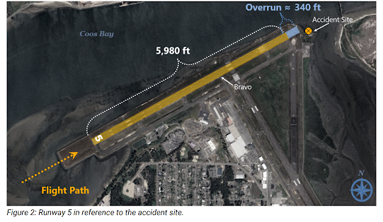
A review of the ADS-B data showed that at 0606:14, the airplane touched down on the runway near the aiming point markings. The airplane continued down the centerline, decelerating from a ground speed of about 128 knots to 125 knots, which was the last recorded hit (near taxiway Bravo). A visual examination of the runway surface revealed no evidence of skid marks or indications of the anti-skid braking system operating. Light tire tracks were observed on the overrun area and through the grass with no indication of braking. The left tire track was about 23ft from the end of the localizer antenna structure; the distance from the left winglet to the left tire is about 15ft (see figure 1). 


Located on the north side of the airport, runway 5 is oriented northeast-southwest and is 5,980 ft long by 150 ft wide (see figure 2). The runway is constructed of grooved asphalt/concrete and has a listed Landing Distance Available (LDA) of 5,320ft, which excludes the 660 ft length of the displaced threshold for runway 23. The overrun area is about 340 ft, followed by about 100 ft of grass and rocks between the end of the pavement and the water.


The airplane had been upgraded with the Honda Aircraft Company Airplane Flight Manual (AFM) Supplement, "Wet and Contaminated Runway Performance" for the HondaJet ELITE S (Revision A, dated July 20, 2023). The logbooks indicated the software had been upgraded in the FMS to reflect the revised AFM. The definition contained in the supplement for “wet runway” is then “water depth on the runway is less than 0.125 inch.”


The VREF and landing distance required were calculated from the AFMS based on the temperature of 11°C, the self-reported weight of 9,000 lbs, a “wet” runway, negligible tail/head wind, a runway slope gradient of 0.05%, and an airport altitude of 16 ft. The AFMS provided a required landing distance of 5,910 ft, and a VREF of 111kts.


The airplane was not equipped with thrust reversers or spoilers. During landing, the speed brake was deployed; the emergency braking system was not used. The initial examination of the wheels and braking system revealed no evidence of failures, excessive wear, or malfunctions. Investigators removed components from the airframe to be tested at a later date.


A preliminary comparison of prior flights and the accident flight was performed (see figure 3). The accident flight was similar to the previous flights, aside from a slightly higher ground speed at touchdown.

Cessna T207 Turbo Skywagon, N91025, fatal accident occurred on April 18, 2025, at Nanwalek Airport (KEB), Nanwalek, Alaska

This is preliminary information, subject to change, and may contain errors. Any errors in this report will be corrected when the final report has been completed.

Aviation Accident Preliminary Report - National Transportation Safety Board

The National Transportation Safety Board travelled to the scene of this accident.

Investigator In Charge (IIC): Rasmussen, Mitchell

Additional Participating Entities:

Tom Johnson; FAA FSDO Juneau; Ketchikan, AK

https://registry.faa.gov/AircraftInquiry/Search/NNumberResult?nNumberTxt=N91025

https://data.ntsb.gov/carol-repgen/api/Aviation/ReportMain/GenerateNewestReport/200076/pdf

Arctic Aviation Leasing LLC

  • Location: Nanwalek, AK 
  • Accident Number: ANC25FA035 
  • Date & Time: April 28, 2025, 13:55 Local 
  • Registration: N91025 Aircraft: Cessna T207 
  • Injuries: 2 Fatal, 1 Serious
  • Flight Conducted Under: Part 135: Air taxi & commuter - Scheduled

On April 28, 2025, about 1355 Alaska daylight time, a Cessna T207 airplane, N91025, was substantially damaged when it was involved in an accident near Nanwalek, Alaska. The pilot and one passenger were fatally injured. One passenger was seriously injured. The airplane was operated as flight number 213, a Title 14 Code of Federal Regulations Part 135 scheduled commuter air carrier flight.

According to the operator, Smokey Bay Air, the pilot and two passengers departed the Homer Airport, Homer, Alaska, en route to the Nanwalek Airport, Nanwalek with 40 gallons of aviation fuel on board, 271 lbs of passenger baggage, and 257 lbs U.S. mail on board.

Archived Federal Aviation Administration (FAA) Automatic Dependent Surveillance-Broadcast (ADS-B) data shows the airplane departing Homer, crossing Kachemak Bay and following the coastline before approaching Runway 19 in Nanwalek from the North.

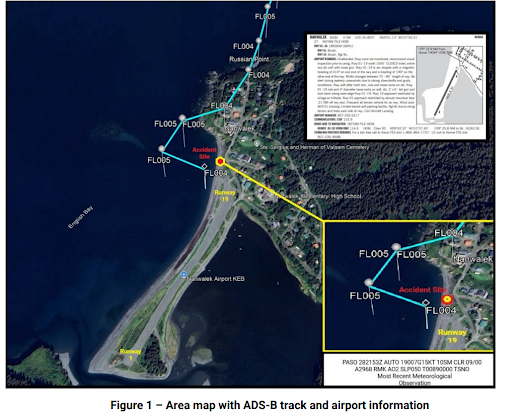
The ADS-B track data then shows that, as the airplane approached Nanwalek Airport from the north, it momentarily sidestepped to the right of the runway centerline, which was followed by a left turn once it was parallel with the approach end of Runway 19. The airplane was about 100 ft above ground level (AGL) at the final ADS-B captured datapoint (See figure 1).

Multiple witnesses, located on the ground in the vicinity of the airport, reported seeing the airplane approaching Runway 19 for landing, from over the village. The witnesses then stated that the airplane increased throttle and entered a steep left bank near the North end of Nanwalek Airport before losing control and spiraling down to the ground. Some witnesses reported seeing a dog on the runway when the accident airplane was on final approach.

A pilot, in a second Smokey Bay Airplane a few miles in trail of the accident airplane also inbound to Nanwalek Airport, recalled hearing the accident pilot state, over the radio, “I’m going around, there’s something on the runway,” just before the accident.

The surviving passenger was later interviewed at a hospital in Anchorage, Alaska. He reported approaching Nanwalek Airport from the village side and recalled that the airplane was offset to the right of runway centerline on final approach. He then stated that the airplane entered a sharp, steeper than normal, left banking turn before losing control and rapidly spiraling down to the surface (See figure 2).

The airplane came to rest on the beach about 350 ft northwest of the approach end of Runway 19. First responders subsequently pulled the airplane wreckage to higher ground to keep the airplane from becoming submerged as the tide began to rise.

The left wing was separated from the fuselage, held only by the control cables, and rotated forward of the main wreckage. The right wing exhibited spanwise deformation to the outboard section, beyond the lift strut, consistent with impact damage. Both the aft section of the fuselage, forward of the empennage, and the nose section of the fuselage, forward of the cockpit, exhibited damage consistent with rotational forces on impact.

During the onsite investigation, no preimpact anomalies were visually observed with the flight control system. The flap selector was found in the full down position. The three propeller blades exhibited rotational signatures.

The wreckage has been recovered to a secure facility for further examination.

D'Apuzzo D-295 Senior Aero Sport, N321WC, accident occurred on April 19, 2025, near Phoenix Deer Valley Airport (DVT/KDVT), Phoenix, AZ

 This is preliminary information, subject to change, and may contain errors. Any errors in this report will be corrected when the final report has been completed.

Aviation Accident Preliminary Report - National Transportation Safety Board

The National Transportation Safety Board did not travel to the scene of this accident.

Investigator In Charge (IIC): Nepomuceno, Eleazar

Additional Participating Entities:

Scott Boek; Federal Aviation Administration; Scottsdale, AZ 

Mark Platt; Lycoming; Phoenix, AZ 

https://registry.faa.gov/AircraftInquiry/Search/NNumberResult?nNumberTxt=N321WC

https://data.ntsb.gov/carol-repgen/api/Aviation/ReportMain/GenerateNewestReport/200044/pdf

N321 Whiskey Charlie LLC

  • Location: Phoenix, AZ 
  • Accident Number: WPR25LA136 
  • Date & Time: April 19, 2025, 11:06 Local 
  • Registration: N321WC 
  • Aircraft: D'Apuzzo Senior Aero Sport 
  • Injuries: 1 None 
  • Flight Conducted Under: Part 91: General aviation - Personal 

On April 19, 2025, about 1106 Pacific daylight time, an experimental amateur built D'Apuzzo Senior Aero Sport, N321WC, was substantially damaged when it was involved in an accident near Phoenix, Arizona. The pilot was not injured. The airplane was operated as a Title 14 Code of Federal Regulations Part 91 personal flight.

The pilot reported after completing a thorough preflight inspection and adding fuel to the main saddle tanks. The pilot departed runway 7R at Phoenix Deer Valley Airport, Phoenix, Arizona, with the intention of staying in the airport traffic pattern, to “exercise the airplane.” During an approach for a third touch and go takeoff and landing, the pilot initiated a go-around at the direction of the air traffic control tower controller. As he turned onto the downwind leg for runway 7R, about 1,000 ft above the ground (agl), the engine RPM surged multiple times followed by a total loss of engine power. The pilot turned the electric fuel boost pump on (both high and low speed settings) and cycled the throttle and mixture lever settings, but the engine did not restart.

About 700 ft agl, the pilot turned towards the airport and declared an emergency, in which he was immediately cleared by a tower controller to land on runway 25R. The pilot realized that he would not be able to make it to the airport and initiated a forced landing onto a road. During the off-airport landing sequence, the pilot the pilot maneuvered from the road to avoid a vehicle, and the airplane impacted a carport roof. Subsequently the airplane came to rest nose down in a parking lot. Postaccident examination of the airplane revealed that both lower wings were substantially damaged.

The airplane was recovered to a secure location for further examination.