- Location: Tabor City, NC
- Accident Number: ERA25FA228
- Date & Time: June 14, 2025, 12:45 Local
- Registration: N82UC
- Aircraft: Beech 58
- Injuries: 2 Fatal
- Flight Conducted Under: Part 91: General aviation - Personal
https://registry.faa.gov/AircraftInquiry/Search/NNumberResult?nNumberTxt=N82UC
On June 14, 2025, at 1245 eastern daylight time, a Beech 58 airplane, N82UC, was destroyed when it was involved in an accident near Tabor City, North Carolina. The private pilot and passenger were fatally injured. The airplane was operated as a Title 14 Code of Federal Regulations Part 91 personal flight.
The instrument-rated private pilot departed on an instrument flight rules flight from Spartanburg Downtown Memorial Airport/Simpson Field (SPA), Spartanburg, South Carolina at 1120 and was enroute to Grand Strand Airport (CRE), North Myrtle Beach, South Carolina, which was located about 170 nautical miles (nm) to the southeast.
Preliminary Automatic Dependent Surveillance-Broadcast (ADS-B) data and air traffic control communications showed that the enroute portion of the flight was normal and unremarkable. The pilot flew a track of about 100°, at an altitude of 7,000 ft mean sea level (msl), and 190 knots groundspeed; during this time the pilot was in communications with the Myrtle Beach (MYR) TRACON controller who issued the airport altimeter setting and queried the pilot if he had the current weather information.
The controller instructed the pilot to descend and maintain 4,000 ft msl, which was acknowledged and complied with. The pilot requested a different heading because it looked like they would be heading “straight into” the weather and the controller subsequently issued a heading of 060°. Shortly after, the controller handed the pilot over to the eastern sector radar controller, who approved deviations left and right of course as needed.
The pilot arrived in the vicinity of the airport and was preparing for an instrument approach. The controller approved additional deviations to the pilot as needed to avoid heavy precipitation and gave the pilot subsequent headings that would put the airplane on a heading to intercept the final approach course for the ILS approach to runway 23.
During this time, light rain was developing over CRE, and heavy precipitation had begun near the departure end of runway 23, along with wind gusts to 25 knots. The controller instructed the pilot to turn right to 140° and descend and maintain 1,700 ft msl. The pilot asked the controller to repeat the instructions which the controller did; the pilot acknowledged. Shortly after, the pilot was cleared for the ILS runway 23 approach and was instructed that in the event of a go-around, to fly heading 090° and maintain 2,000 ft msl, which was acknowledged.
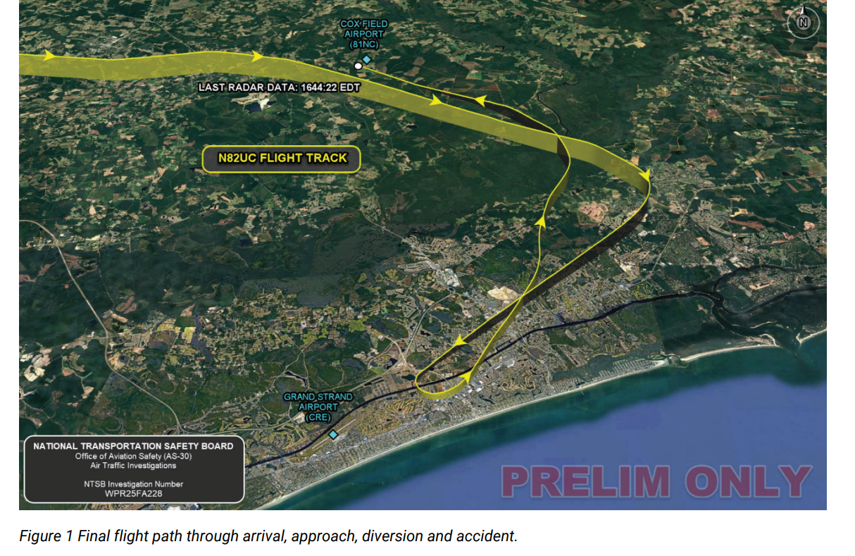
As the airplane approached a 1 1/2-mile final, while descending through 800 ft msl, the pilot abandoned the approach and performed a left climbing turn to the north-northeast while climbing to 2,600 ft msl. The controller asked the pilot his intentions and the pilot responded by asking the controller to suggest a heading to get out of the weather and that they wanted to divert to Florence Regional Airport (FLO), Florence, South Carolina, about 55 nm to the westnorthwest. The controller provided a heading of 350° and to maintain 3,000 ft msl.
About 5 nm miles into the diversion, while at 3,000 ft msl, the pilot turned to a track of about 310° and began a descent; the airplane’s speed increased steadily from 160 knots to about 235 knots groundspeed in a steady straight-line descent. The controller attempted to contact the pilot; however, there was no response. Multiple transmissions were heard that included engine noise and inaudible conversation, but there was no direct pilot-to-controller communication from this point forward. No other communications were received, and radar contact was subsequently lost. The airplane’s descent rate went from -600 feet per minute (fpm) to -4,500 fpm until there was a brief arrest of the descent where it decreased to -300 fpm after which the descent rate increased again to -4,000 fpm until the ADS-B data ended. (Figure 1) During the final descent, there were no observed maneuvers or significant heading changes. The tree impact signatures at the accident site indicated a descent angle of about 23° and were consistent with the airplane being wings level.
The reported weather conditions at CRE about 5 minutes before the accident included wind from 240° at 20 knots gusting to 30 knots, 1 1/2-mile visibility with heavy thunderstorms, rain, and mist. There were few clouds at 1,000 ft above ground level (agl) and scattered clouds at 2,100 ft agl. The reported temperature and dewpoint were 27° and 26° C, respectively.
At 1244, about the time of the accident, the reported wind was from 240° at 14 knots gusting to 27 knots, 3/4 mile visibility, heavy thunderstorms, rain and mist, few clouds at 800 ft, broken clouds at 1,800 ft and 5,000 ft agl and the reported temperature and dewpoint were 27° and 26° C, respectively.

The airplane impacted a remote and densely wooded area covered with 75 ft-tall mature pine trees at an elevation of 40 ft. The wreckage path was 468 ft-long and oriented on a magnetic heading of 293° and scattered in a tight formation throughout the entire path. The initial impact area was the tops of 75-ft-tall trees with associated tree and limb fractures progressively lower to the terrain; about 30 trees were damaged by the impact. The airplane wreckage was extremely fragmented. All flight control surfaces, wings, empennage, cockpit, and engine assemblies were impact-separated and strewn throughout the accident site. The largest item discovered at the accident site was a portion of the aft right fuselage that contained an entry step and door. There was no fire.
The accident site had the slight odor of aviation fuel and fuel blight was observed on the surrounding vegetation.
A majority of flight control surfaces and major components were identified and accounted for at the accident site, although all were severely fragmented and damaged. Flight control continuity could not be confirmed on site due to the severity of the damage; however, all control cables that were observed exhibited features consistent with tensile overload and a “broom straw” appearance. No indications of flight control anomalies were discovered during the accident site examination. Flight control trim settings were inconclusive.
Both propeller assemblies separated from the engines and exhibited features consistent with impact and rotational damage. Both propellers showed signs of s-bends, chordwise scraping, leading edge gouges and trailing surface waves.
Both engines separated from their respective firewall and were impact-damaged and discovered in close proximity to each other. Both engines showed significant impact damage.
Two data cards were discovered in different locations at the accident site. The Garmin G1000 unit, which was severely damaged, was missing its data cards from their respective slots. The recovered cards were retained for examination and download.
The wreckage was retained for further investigation.
No comments:
Post a Comment