Wednesday, July 02, 2025

Cessna 208B Supervan 900, N716MM, accident occurred on July 2, 2025, near Cross Keys Airport (17N), Cross Keys, New Jersey

This is preliminary information, subject to change, and may contain errors. Any errors in this report will be corrected when the final report has been completed.

https://registry.faa.gov/AircraftInquiry/Search/NNumberResult?nNumberTxt=N716MM

Arne Aviation LLC


- History of Flight:
On July 2, 2025, at about 1723 local time, a Cessna 208B Supervan 900, registered to Arne Aviation LLC out of Suffolk, Virginia, N716MM, sustained substantial damage when it impacted trees following a runway overrun at Cross Keys Airport (17N), Cross Keys, New Jersey. There was one pilot and thirteen passengers onboard. Five occupants received unspecified injuries. The flight was being conducted as a 14 Code of Federal Regulations Part 91 skydiving flight.

According to preliminary flight-track history, earlier in the day, at about 1629 LT, the airplane departed 17N on an 18-minute flight. It departed runway 27 and conducted a climbing right turn to an altitude of 3,000 ft before it preceded to the east and continued flying until it reached 8,000 ft. At this point, it turned around, while still climbing, and overflew the airport at an altitude of 13500 ft, where it presumably dropped the skydivers. The airplane then flew south of the airport, conducted two orbits, then proceeded to land on runway 27.

Later in the day, at about 1519 LT, the airplane departed runway 27 on the accident flight. It conducted a climbing right turn to an altitude of 3,000 ft, before it stopped the climb and started flying northwest (back to the airport). At 1523:07, the airplane was at 1675 ft, 112 knots, and descending towards the runway when it entered a orbit. The airplane briefly climbed to 1750 ft before it started to descent. At the conclusion of the orbit, at 1723:41, the airplane was at 1025 ft, 96 knots, and descending -2600 fpm. The last ADS-B return was recorded 7 seconds later at 1723:48. The airplane was at 525 ft, 111 knots groundspeed, and descending 3100 fpm. It was recorded less than 0.20 mile from the runway 27 threshold. (figure 1)

The airplane impacted trees off the departure end of runway 27. There was no post crash fire.

Figure 1: ADS-B data

- Pilot Info:
UNKNOWN AT THIS TIME

- Wreckage and Impact Information:
UNKNOWN AT THIS TIME

- Aircraft Info:
The accident aircraft, MSN 208B0746, was powered by a Honeywell TPE331-12JR engine, rated at 900 Horsepower.

According to NTSB records, the airplane was involved in an accident on 3 July 2023 at Suffolk Executive Airport (KSFQ), Virginia, when it suffered a nose gear collapse. (look in "additional information" for the accident narrative). At the time, the airplane was equipped with 12 seats, and the certified Max Gross Weight was 9062 lbs. The total airframe hours were 9519.

- Airport Info:
Cross Keys Airport (17N) is a privately-owned, public use airport located one nautical mile south of the Cross Keys, New Jersey. The airport is commonly used for skydiving operation. It features one runway designated 9/27 with an asphalt surface measuring 3,500 by 50 feet. The airport elevation was 162 ft.

One airport remark states; "Due to parachute drop zone on north side of airport, all traffic to remain south of runway 09/27."

- Weather:
Weather conditions at KPHL, located 14 nautical miles away from 17N, at 1656 local time, were reported to be, in part: wind 210° at 8 knots; visibility 10 statute miles; few clouds at 3,500 feet. A scattered ceiling at 7,000 ft. Two broken layers at 23,000 ft, and 35,000 ft, temperature: 30°C, dewpoint: 21°C, and an altimeter setting of 29.85 inches of mercury.

METAR KPHL 022054Z 21008KT 10SM FEW035 SCT070 BKN230 BKN350 30/21 A2985 RMK AO2 SLP107 T03000206 56012 $

METAR KPHL 022154Z 21007KT 10SM FEW040 SCT075 SCT230 BKN350 31/21 A2985 RMK AO2 SLP107 T03060206 $

- Additional Information:
2010 Accident:
On 10 October 2010, the airplane was being operated by Makalu Air in Nepal when it was involved in a runway excursion at Simikot Airport (IMK/VNST). The nose and right main gear collapsed.

2023 Accident:
The pilot was returning from her fifth skydive run of the day. During the landing, 'the flare seemed insufficient' and the nose landing gear collapsed during touchdown. The airplane continued off the side of the runway and came to rest in the grass. During the accident sequence, the airplane sustained substantial damage to the engine mounts.

The NTSB determined the probable cause to be; "The pilot's inadequate landing flare, which resulted in a nose landing gear collapse."

Robinson R66 Turbine, N962MD, fatal accident occurred on June 4, 2025, near Kaparuk, Alaska

  • Location: Kaparuk, AK 
  • Accident Number: ANC25FA044 
  • Date & Time: June 4, 2025, 10:55 Local 
  • Registration: N962MD 
  • Aircraft: ROBINSON HELICOPTER CO R66 
  • Injuries: 2 Fatal 
  • Flight Conducted Under: Part 135: Air taxi & commuter - Scheduled

https://registry.faa.gov/AircraftInquiry/Search/NNumberResult?nNumberTxt=N962MD

https://data.ntsb.gov/carol-repgen/api/Aviation/ReportMain/GenerateNewestReport/200266/pdf

On June 4, 2025 about 1055 Alaska daylight time, a Robinson R66 turbine-powered helicopter, N962MD, was substantially damaged when it was involved in an accident near Kaparuk, Alaska. The pilot and passenger were fatally injured. The helicopter was operated as a Title 14 Code of Federal Regulations Part 135 on-demand charter flight.

The helicopter was operated by Pollux Aviation, Wasilla, Alaska, and according to the director of operations, the flight was part of a contract conducting bird research. The purpose of the flight was to scout conditions in the local area, and the next day they planned to relocate to a remote work camp within the North Slope region for three weeks. The pilot was new to the company and flew from Wasilla to Deadhorse Airport (PASC), Deadhorse, Alaska, the day before the accident. The accident flight was his first flight on the North Slope with a passenger.

The Alaskan North Slope is bounded on the north by the Beaufort Sea and runs from the Canadian border to the maritime boundary with Russia in the west. The North Slope region includes a portion of the Arctic National Wildlife Refuge (ANWR) and National Petroleum Reserve-Alaska (NPRA).

Weather conditions at PASC when the accident helicopter departed were reported to be, in part: wind 080° at 6 knots; visibility 10 statute miles; overcast ceiling of 500 feet. The pilot received a weather briefing prior to departure. 

According to archived Federal Aviation Administration (FAA) communication data, prior to departure, the accident pilot contacted the Deadhorse Flight Service Station (SCC FSS) specialist on-duty to request a special visual flight rules (SVFR) clearance to depart to the west. The specialist on duty issued the pilot a SVFR clearance and instructed him to report clear of the Class E airspace to the west. The helicopter then departed to the west.

When the helicopter was about 15 miles west of PASC, the pilot informed the SCC FSS specialist that the helicopter was clear of the airport environment to the west.

No further radio contact was received from the accident helicopter. 

According to archived automatic dependent surveillance-broadcast (ADS-B) data, after the helicopter departed PASC, it proceeded west to an area about 25 miles away, and the altitude ranged from about 300 to 600 ft mean sea level (msl). The data ends at an altitude of 575 ft msl, and during a left turn to the southwest. 

After an emergency locater transmitter (ELT) signal was received and attempts to reach the crew were unsuccessful, a North Slope Borough (NSB) Search and Rescue Sikorsky S-92 helicopter was dispatched from Utqiagvik (formerly Barrow), Alaska to search for the helicopter. NSB search and rescue crews found the helicopter wreckage about 25 miles west of Deadhorse in an area of flat, snow-covered, featureless terrain. See figure 1

A review of preliminary weather data revealed conditions, about two miles from the accident site were 500 ft overcast, and 10 statute miles visibility.

On June 5, an investigator from the National Transportation Safety Board's (NTSB) Alaska Regional Office traveled to Deadhorse, but travel to the accident site by helicopter was delayed due to poor weather conditions until June 7. Once on scene, the NTSB investigator documented the helicopter wreckage before recovery efforts began. 

An initial examination of the helicopter wreckage revealed that all the helicopter’s components were found at the accident site. The main wreckage came to rest about 11 feet from the initial impact point, and it showed significant down-stroking impact damage. One main rotor blade was found about 140 ft to the left of the main wreckage, and the other main rotor blade remained attached to the helicopter’s main rotor hub. See figure 2

Continuous poor weather conditions delayed the wreckage recovery until June 9. The wreckage was initially slung by helicopter to PASC, then transported to Anchorage for further examination and testing. A detailed wreckage examination is pending.

Cessna 172K Skyhawk, N79306, fatal accident occurred on June 19, 2025, near Billings, Montana

  • Location: Billings, MT
  • Accident Number: WPR25FA182 
  • Date & Time: June 19, 2025, 14:12 Local 
  • Registration: N79306 Aircraft: 
  • Cessna 172 Injuries: 1 Fatal 
  • Flight Conducted Under: Part 91: General aviation - Personal

https://registry.faa.gov/AircraftInquiry/Search/NNumberResult?nNumberTxt=79306

https://data.ntsb.gov/carol-repgen/api/Aviation/ReportMain/GenerateNewestReport/200353/pdf

On June 19, 2025, at 1412 mountain daylight time, a Cessna 172K airplane, N79306, was destroyed when it was involved in an accident near Billings, Montana. The pilot was fatally injured. The airplane was operated as a Title 14 Code of Federal Regulations (CFR) Part 91 personal flight.

Preliminary ADS-B data provided by the Federal Aviation Administration showed that the airplane departed Ostlunds Airport, Billings, Montana at 1407 in a climbing left turn to the southeast. At 1411 the airplane overflew a private ranch and the flight track subsequently ended at 1412 about 230 ft southeast of the accident site.

The airplane came to rest underneath a set of damaged power distribution lines on the floor of a coulee. The debris field was contained within about a 75 ft by 75 ft area. The first identified point of contact (FIPC) was a ground scar consistent with the leading edge of the left wing. Red colored glass fragments consistent with the left wingtip navigation light were noted at the outboard end of the ground scar. 

The main wreckage was upright, about 18 ft from the FIPC, and was oriented on an approximate heading of 200° magnetic, at an elevation of 3,770 ft mean sea level. Evidence of a postcrash fire was observed throughout the wreckage. 

All major components of the airframe, all primary flight controls, and the engine and propeller assembly were observed throughout the debris field. Flight control continuity was established on scene. The elevator trim was found to be in the neutral position, and flaps were observed in the fully retracted position. Both fuel tanks sustained hydraulic deformation consistent with the tanks containing a quantity of fuel at the time of impact. Postaccident examination of the airframe and engine revealed no preimpact mechanical anomalies or malfunctions that would have precluded normal operation.

The wreckage was transported to a secure location for further examination.

Piper J3C-65 Cub, N28DR, fatal accident occurred on June 24, 2025, near Dunlap, Tennessee

  • Location: Dunlap, TN
  • Accident Number: ERA25FA239 
  • Date & Time: June 24, 2025, 18:23 Local 
  • Registration: N28DR 
  • Aircraft: Piper J3C-65 
  • Injuries: 1 Fatal, 1 Serious 
  • Flight Conducted Under: Part 91: General aviation - Instructional

https://data.ntsb.gov/carol-repgen/api/Aviation/ReportMain/GenerateNewestReport/200387/pdf

https://registry.faa.gov/AircraftInquiry/Search/NNumberResult?nNumberTxt=N28DR

On June 24, 2025, about 18:23 central daylight time, a Piper J3C-65, N28DR, was substantially damaged when it was involved in an accident near Dunlap, Tennessee. The commercial pilot was fatally injured and the passenger was seriously injured. The airplane was operated as a Title 14 Code of Federal Regulations Part 91 instructional flight.

According to the passenger, the purpose of the flight was to continue instructional training that he had started a couple of days prior to the accident. Regarding the accident flight, he recalled that they were at a nearby airstrip about 7 miles north of the accident location. He does not recall departing that airfield, the accident flight, or the accident events. 

The accident site was located at the airplane owner’s private airstrip, about 40 feet to the left side of the runway. The runway heading was 240° and the airplane came to rest on a 335° heading. The airplane came to rest mostly upright in a hay field. A ground scar was observed directly in front of the airplane’s engine and was 8 inches deep. The scar was centered with the airplane and protruded to the airplane’s right by 2 feet. The right main landing gear collapsed, and the airplane was partially resting on the right wing. The cockpit instrumentation, firewall, and engine were displaced upwards from the fuselage. 

Witnesses that responded to the accident site confirmed that the fuel selector was in the “both” position. One witness reported that the forward occupant was wearing the installed four-point harness, and the aft seat occupant was not wearing a harness or lap belt, but that the lap belt was in close proximity to the occupant. A second witness recalled that the aft seat occupant had the lap belt secured, but the shoulder harnesses were not utilized. First responders that documented the scene noted several broken tree limbs with yellow paint transfer about 113ft from the main wreckage.

A postaccident examination of the airframe and engine was conducted. There were no preaccident mechanical malfunctions or failures found with the engine that would have precluded normal operation. An examination of the airframe revealed damage to the left-wing leading edge with tree foliage found underneath the damaged skin, consistent with the tree foliage at the location of the broken tree limbs exhibiting yellow paint transfer. A puncture hole through the top and bottom of the left wing forward and at the outboard side of the left aileron was observed.

A Garmin GPSmap396 was recovered and retained.  

The grass runway measured 40ft in width. A clearing at the beginning of the runway measured about 100ft wide and was about 50ft from the cut grass on the runway. According to the Federal Aviation Administration, the airstrip was about 2,100ft in length.

de Havilland Canada DHC-6 Twin Otter 100, N166DH, accident occurred on June 8, 2025, near Tullahoma Regional Airport/William Northern Field (THA/KTHA), Tullahoma, Tennessee

https://registry.faa.gov/AircraftInquiry/Search/NNumberResult?nNumberTxt=N166DH

https://data.ntsb.gov/carol-repgen/api/Aviation/ReportMain/GenerateNewestReport/200284/pdf

  • Location: Tullahoma, TN 
  • Accident Number: ERA25LA222 
  • Date & Time: June 8, 2025, 12:20 Local 
  • Registration: N166DH 
  • Aircraft: DEHAVILLAND DHC-6 TWIN OTTER 
  • Injuries: 6 Serious, 15 None 
  • Flight Conducted Under: Part 91: General aviation - Skydiving

On June 8, 2025, about 1220 central daylight time, a DeHavilland DHC-6 Twin Otter, N166DH, was involved in an accident near Tullahoma, Tennessee. The commercial pilot and five passengers were seriously injured, and 15 passengers were not injured. The flight was being conducted as a 14 Code of Federal Regulations Part 91 skydiving flight.

The pilot was attempting to take off from runway 24 at the Tullahoma Regional Airport (THA), Tullahoma, TN. The accident flight was his fourth flight in the airplane that day. The pilot stated the takeoff was normal and he raised the flaps once the airplane was clear of obstacles. When the airplane was about 500 ft above the ground, the pilot noticed asymmetrical thrust on the engines while syncing the propellers. He said, “In the following seconds, I continued trying to sync the props and was getting unusual feedback in the controls. I didn’t notice any loss of power in the gauges, but something felt a miss.” The pilot lowered the nose of the airplane and saw the altitude level off, and airspeed decrease.

The pilot determined that the left engine had lost power. He initiated “engine out procedures” and turned left, back to the airport to try and land on runway 36. The pilot could not remember if he secured the left engine; however, he did remember adding flaps as per the engine-out procedures. The pilot said he tried to maintain airspeed above the single engine minimum control speed (Vmc), but the airplane continued to descend. The pilot was unable to make it back to the airport and chose to land in a field. There were two trees in the field that he was unable to avoid, and the airplane impacted the trees. The airplane came to rest upright, but the left wing, left engine and the tail section separated from the airframe, resulting in substantial damage. The right wing and engine remained secured to the airframe. There was no postimpact fire.

The airplane wreckage was recovered and taken to a secure facility for further examination.

Piper PA-22-135 Tri-Pacer, N2300A, accident occurred on June 26, 2025, at Avenger Field Airport (SWW/KSWW), Sweetwater, Texas

This is preliminary information, subject to change, and may contain errors. Any errors in this report will be corrected when the final report has been completed.

https://registry.faa.gov/AircraftInquiry/Search/NNumberResult?nNumberTxt=N2300A

On June 26, 2025, at about 1219 local time, a privately-registered Piper PA-22-135 Tri-Pacer, N2300A, sustained substantial damage in an accident at Avenger Field Airport (SWW/KSWW), Sweetwater, Texas. The pilot and passenger were not injured. The personal flight originated from Aero Valley Airport (52F), Roanoke, Texas, at about 1032 LT.

The FAA reported that the aircraft landed and veered off runway due to winds damaging the left wing, tail and landing gear.

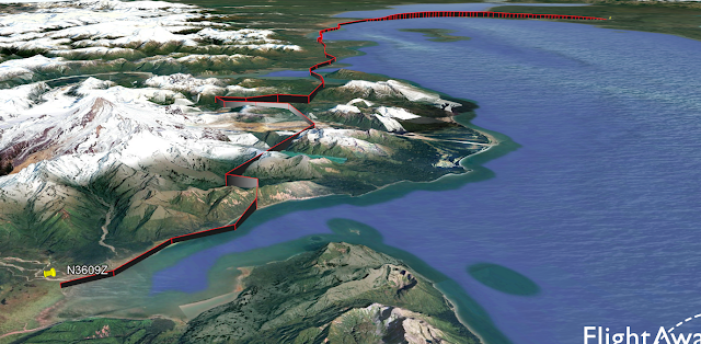
Piper PA-22-150 Tri-Pacer, N3609Z, accident occurred on June 30, 2025, near Chinitna Bay, Alaska

This is preliminary information, subject to change, and may contain errors. Any errors in this report will be corrected when the final report has been completed.

https://registry.faa.gov/AircraftInquiry/Search/NNumberResult?nNumberTxt=N3609Z

Figure 1: ADS-B data from Flightaware

On June 30, 2025, at about 1617 local time, a privately-registered Piper PA-22-150 Tri-Pacer, N3609Z, sustained substantial damage in a forced landing near Chinitna Bay, Alaska. The pilot was not injured. The personal flight originated from Soldotna Airport (SXQ/PASX), Soldotna, Alaska, at about 1457 LT.

ADS-B data indicates the airplane departed runway 25 and climbed to an altitude of 4,000 ft before it descended to about 1,200 ft and started flying towards the southwest. The airplane flew over mountainous terrain with varying degrees of altitudes and groundspeeds. About 55 minutes into the flight, the airplane climbed to an altitude of 2,700 ft to overfly a mountain, which was followed by a slow descent towards a beach.

The FAA reported that the aircraft made an emergency landing on a beach and flipped over.

Tuesday, July 01, 2025

Rans S-14 Airaile, N981CS, fatal accident occurred on June 30, 2025, near Guthrie, Oklahoma

This is preliminary information, subject to change, and may contain errors. Any errors in this report will be corrected when the final report has been completed.

https://registry.faa.gov/AircraftInquiry/Search/NNumberResult?nNumberTxt=N981CS


On June 30, 2025, at about 2055 local time, a privately-registered Rans S-14 Airaile, N981CS, sustained substantial damage when it impacted terrain near Guthrie, Oklahoma. The pilot sustained fatal injuries.

The circumstances of the accident are unknown. The aircraft, serial number A122184, was registered as a Light Sport Aircraft (LSA). It was equipped with a Rotax 503 engine, radio and transponder, 13 gallons of fuel on each wing tank and electric trim and flaps. It was not equipped with ADS-B.

The airplane came to rest upright in an open field and was not consumed by a post crash fire. All four corners of the aircraft were present at the accident site. No debris field was noted. The cockpit was crushed aft and sustained extensive impact damage, both wings remained attached to the airframe, and both sustained accordion style, leading edge impact damage, The tail section was suspended in the air and was not damaged during the impact sequence.

According to the United States Naval Observatory, the official sunset occurred at 2050, end of civil twilight at 2120. At the time of the accident the Sun was 1 degrees below the horizon, and the Moon was 41 degrees over the horizon.

- Weather:
METAR KGOK 010053Z AUTO 05003KT 10SM CLR 27/21 A3002 RMK AO2 SLP155 T02720206 $
METAR KGOK 010153Z AUTO 00000KT 10SM CLR 25/22 A3005 RMK AO2 SLP167 T02500217 $
METAR KGOK 010253Z AUTO 09003KT 10SM CLR 25/21 A3006 RMK AO2 SLP171 T02500206 51026 $

Piper PA-23 Apache, N2109P, accident occurred on June 4, 2025, near Palm Bay, Florida

  • Location: Palm Bay, FL 
  • Accident Number: ERA25LA217 
  • Date & Time: June 4, 2025, 13:41 Local 
  • Registration: N2109P 
  • Aircraft: Piper PA-23 
  • Injuries: 1 Minor, 1 None 
  • Flight Conducted Under: Part 91: General aviation - Personal

https://registry.faa.gov/AircraftInquiry/Search/NNumberResult?nNumberTxt=2109P

https://data.ntsb.gov/carol-repgen/api/Aviation/ReportMain/GenerateNewestReport/200265/pdf

On June 4, 2025, at 13:41 eastern daylight time, a Piper PA-23, N2109P, was substantially damaged when it was involved in an accident near Palm Bay, Florida. The commercial pilot was uninjured, and the sole passenger received minor injuries. The airplane was operated as a Title 14 Code of Federal Regulations Part 91 personal flight.

According to the pilot, they had departed in the morning from the Front Royal-Warren County Airport (FRR), Front Royal, Virginia, and were heading to Boca Raton, Florida. The pilot reported that prior to departing FRR, they had filled both main fuel tanks for a total of 72 gallons of fuel. The pilot also reported that due to a fuel leak, the auxiliary fuel tanks were not used. During the flight, the pilot made a fuel stop at the Orangeburg Municipal Airport (OGB), Orangeburg, South Carolina, where they took on 60.3 gallons of fuel to top off the main fuel tanks. After departing OGB, the flight continued south. When the flight approached Savannah, Georgia, the pilot reported encountering a patch of weather and diverted to the west to go around it. After passing the weather, the pilot began to follow the coastline, and as the airplane approached the Daytona Beach area, the pilot diverted to the east to avoid another patch of weather. Shortly afterward, the pilot began to make an approach to their next fuel stop at the Valkaria Airport (X59), Valkaria, Florida. While on approach to X59, the pilot reported entering a “massive rain shower,” and the pilot lost sight of the runway. The pilot aborted the approach and initiated a climb toward the east to exit the weather. After reaching about 1,500 ft mean sea level (msl), the pilot reported that the left engine began to sputter and lost power. The pilot applied carburetor heat and attempted to restart the left engine; however, engine power did not return. The pilot then reported that the right engine began to sputter, and the pilot elected to perform a forced ditching into the Indian River near Palm Bay, Florida. During the ditching, the airplane sustained substantial damage to the fuselage and empennage. The pilot and passenger exited the airplane and swam to shore.

The wreckage was recovered the same day from the river and brought to shore. The following day, the wreckage was examined. Both fuel selectors were found in the “MAIN” fuel tank position. The left main and auxiliary fuel tank caps were found to be secure, and there were no signs of a fuel leak around the fuel tanks. The left main fuel tank was drained at the left fuel strainer bowl, where approximately 7 gallons of water were drained from the fuel tank. There were no signs of fuel in the left main fuel tank. The left auxiliary fuel tank was drained at the strainer, and the tank contained approximately 4 gallons of fuel that had the odor and color consistent with 100 low lead (LL) aviation gasoline; there was no water found in the left auxiliary fuel tank. The left fuel strainer bowl was removed and visually inspected; the strainer bowl cap was found to be severely corroded. There was no fuel screen installed in the left fuel strainer, and the bowl contained several large pieces of corroded debris. 

The right main fuel tank cap was found to be secured to the fuel tank filler and sealed properly. The right auxiliary fuel tank cap was found installed in the right auxiliary tank filler; however, the right auxiliary tank filler neck was missing the metal ring insert and would not seal properly. A lighted borescope was inserted into the right auxiliary fuel tank, and the filler port insert was found near the right auxiliary tank pickup screen. The right main fuel tank was drained at the fuel strainer, where approximately 1 gallon of water and 4 gallons of fuel that had the odor and color consistent with 100LL aviation gasoline were drained from the fuel tank. The right auxiliary fuel tank was found to be completely devoid of fluid.

The wreckage was retained for further examination.

XAG P100 Pro, N231CU, accident occurred on June 5, 2025, near Pontiac, Illinois

  • Location: Pontiac, IL 
  • Accident Number: CEN25LA206 
  • Date & Time: June 5, 2025, 11:55 Local 
  • Registration: N231CU 
  • Aircraft: XAG P100 PRO 
  • Injuries: 1 None 
  • Flight Conducted Under: Part 137: Agricultural
https://registry.faa.gov/AircraftInquiry/Search/NNumberResult?nNumberTxt=N231CU

https://data.ntsb.gov/carol-repgen/api/Aviation/ReportMain/GenerateNewestReport/200318/pdf

On June 5, 2025, at 1155 central daylight time, a XAG P100 Pro, N231CU, was substantially damaged when it was involved in an accident near Pontiac, Illinois. The unmanned aerial system (UAS) was operated under Title 14 Code of Federal Regulations as a Part 137 aerial application flight.

The UAS was in a hover about 10 ft above ground level spraying an agricultural field with fertilizer when a propeller blade separated from the UAS. The UAS then descended and impacted the field. The UAS sustained substantial damage to the propeller.

The portion of the propeller that remained attached to the UAS was retained for further examination.