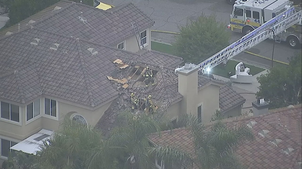
- Location: Simi Valley, CA
- Accident Number: WPR25FA147
- Date & Time: May 3, 2025, 13:50 Local
- Registration: N626PB
- Aircraft: PAUL BERKOVITZ VANS RV-10
- Injuries: 2 Fatal
- Flight Conducted Under: Part 91: General aviation - Personal
https://data.ntsb.gov/carol-repgen/api/Aviation/ReportMain/GenerateNewestReport/200098/pdf
On May 3, 2025, about 1350 Pacific daylight time, an experimental amateur-built Van’s RV-10, N626PB, was destroyed when it was involved in an accident near Simi Valley, California. The pilot and passenger were fatally injured. The airplane was operated as a Title 14 Code of Federal Regulations Part 91 personal flight.
The airplane departed General Wm J. Fox Airfield (WJF), Lancaster, California about 1319, on an instrument flight rules flight plan with an intended destination of Camarillo Airport (CMA), Camarillo, California. Recorded communication between the pilot and Southern California Approach Control revealed that about 1335, the pilot was instructed by the controller to proceed direct SESPE (initial approach fix for the RNAV-Z runway 26 instrument approach) and join final. At about 1343, the controller instructed the pilot to descend to 4,000 ft mean sea level (msl) and to contact Point Mugu Approach.
Preliminary ADS-B data showed that at 1343:50 the airplane crossed SESPE at an altitude of about 5,000 ft msl, before a left turn to a southerly heading was made. The airplane continued a southerly heading while descending to 4,195 ft msl at 1345:33. Shortly after, multiple heading deviations to the right and left were observed throughout the following 1 minute, 5 seconds. At 1346:49, the data showed the airplane began a right turn, while about 1-mile north of JUREX (the RNAV-Z runway 26 intermediate fix) at an altitude of 3,750 ft msl. The airplane continued a right descending turn when ADS-B contact was lost at 1347:02. ADS-B contact was reestablished at 1347:21, with the airplane flying on a northerly heading at an altitude of 2,175 ft msl. The data showed the airplane began a left turn about 4 seconds later, at an altitude of 2,525 ft msl. Throughout the turn, the airplane climbed to a maximum altitude of 2,770 ft msl at 1347:37 before ADS-B contact was lost 6 seconds later. ADS-B contact was reestablished at 1347:53, at an altitude of 1,720 ft msl on a south-southeasterly heading. The last recorded ADS-B data point was at 1347:53, at an altitude of 1,720 ft msl, about .72 miles southwest of the accident site.
One pilot-rated witness to the accident, reported that he was at his home near the accident site and observed that the cloud layer was about 300 ft above ground level (agl.) Cell phone video footage provided by another witness located near the accident site, showed the airplane descending below the cloud layer and subsequently climbing back into the clouds. About 6 seconds later, the video showed the airplane rapidly descending from the clouds in a nose down attitude. Surveillance video footage from the southernmost residence struck by the airplane showed the area of initial impact followed by a subsequent explosion, and a post-crash fire ensued.
The first identifiable point of impact was a set of palm trees located in front of the southernmost residence struck by the airplane. The wreckage debris field was about 221 ft long by 150 ft wide, oriented on a heading of 240° magnetic at an accident site elevation of about 1,070 ft.
About 17 ft from the initial point of impact, an east-west spanning stone block wall, located between two residential structures was damaged. The left wing struck a residential structure on the northern side of the wall, while the right wing struck another residential structure on the south side of the wall. Within the debris from the wall, the empennage, left and right wing spars, and carry-through spar were located. About 4 ft west of the wall, a 7 ft diameter area of disturbed dirt and vegetation was observed, which contained various fragments of engine oil sump and propeller blades. The fuselage came to rest about 17 ft west of the area of disturbed dirt. The engine was located about 10 ft beyond the fuselage. All major structural components of the airplane were located throughout the wreckage debris path.
The wreckage was recovered to a secure facility for further examination.


No comments:
Post a Comment